

Long Term Monitoring - Heron Reef
The basis of our research has revolved around local long term monitoring of coral at Heron Reef since 2002 annually using field and satellite imagery.
See below publications, data and code.

Locations
Heron Reef, Australia
People
Chris Roelfsema (PI), Nick Hammerman, Kirsten Golding, Faye Diederiks, David Carrasco Rivera, Joanna Smart, Dylan Cowley, Kathryn Markey, Mitchell Lyons, Meredith Roe, Paul Tudman, Emma Kennedy, Rodney Borrego, Javier Leon, Emily Shaw, Julie Vercolinie, Stuart Phinn, Eva Kovacs, Denise Perez, Megan Saunders, and Robert Canto
Timeframe
1998 - ongoing
Funding
Various
Summary
Since 2002 annually high spatial resolution airborne and satellite imagery, and geo-referenced photoquadrats have been acquired for Heron Reef. This to develop our understanding of benthic community changes over time and space, and how best to monitor such habitats in the water and from space.
We have developed and improved field methods to collate information on benthic composition, abundance and structure as well as optical properties of the water column and bottom type. This work also involved collecting other physical properties such as wave climate and rugosity.
Additionally, we have integrated data through citizen science-based programs such as: CoralWatch, Reef Check Australia and the Eye on the reef program.
Read about:
Heron Island Research Station Research.
Thousands of Queensland reef photos lead to worldwide change
We acknowledge the traditional custodians of Heron Island and surrounding reef and waters, the Bailai, the Gooreng Gooreng, the Gurang and the Taribelang Bunda peoples and the sea country we are mapping and monitoring. We pay respect to their Elders past, present and emerging.
We also acknowledge the University of Queensland Heron Island Research Station.
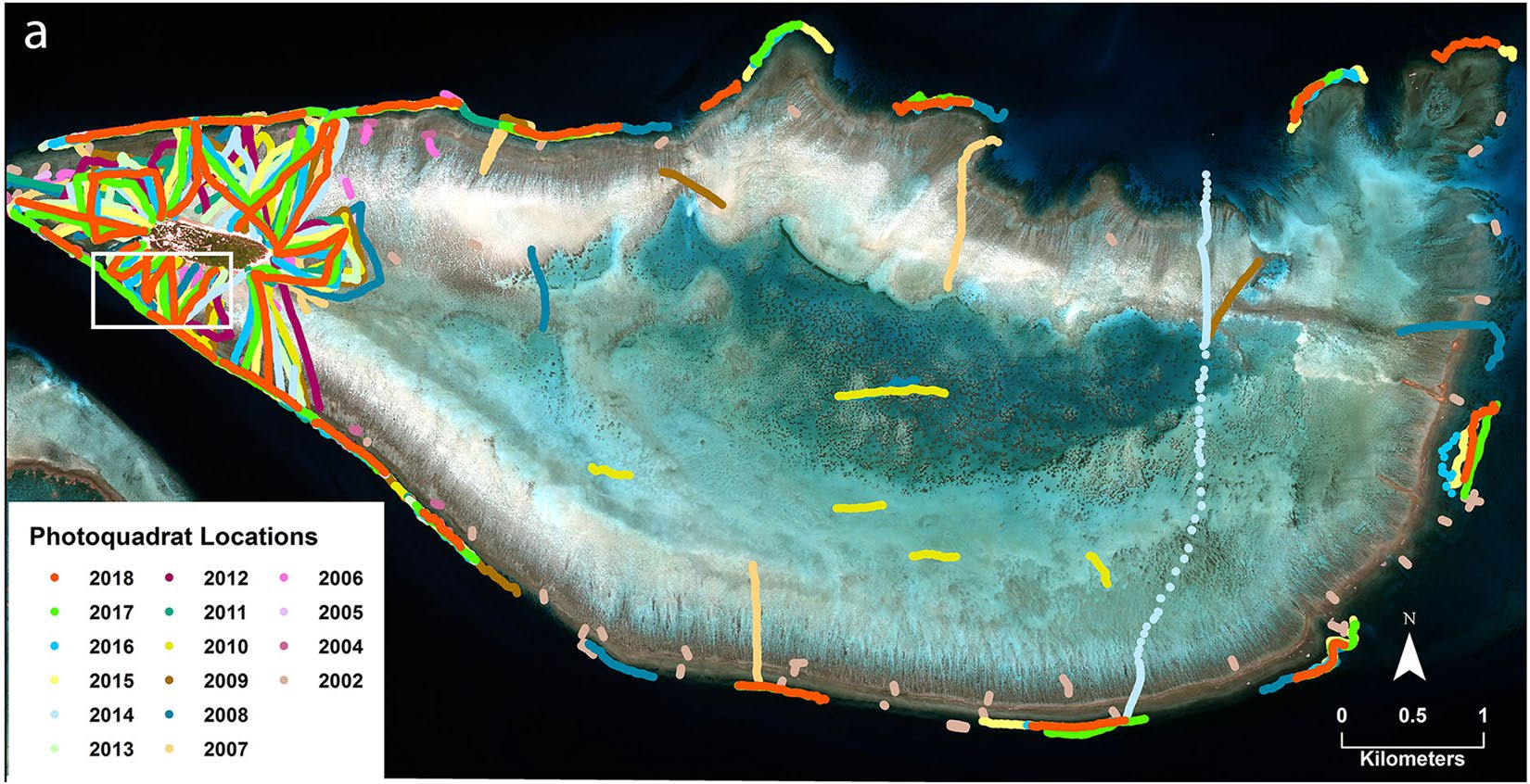
Heron Reef, southern Great Barrier Reef, Australia. Location of photoquadrat transect surveys on Heron Reef collected annually since 2002 and ongoing. (Roelfsema et al 2021, Scientific Data)

Benthic composition created by integrating field photo quadrate with world view 2 imagery and object based analysis for 2007. (Phinn et al 2012)

Annual satellite imagery and georeferenced photoquadrats (clipped to the west side of the reef, outer reef flat and reef slope) for Heron Reef, Australia, from 2002 to 2023. (Carrasco et al., 2025)
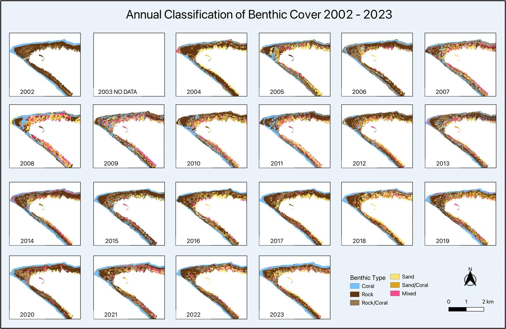
Annual classification of satellite imageries showing the benthic composition of the west portion of the outer reef flat and the reef slope of Heron Reef, Australia. (Carrasco et al., 2025)
Publications
Scientific journals
Hammerman N.M., T. Staples, K.M. Golding1, F.F. Diederiks, D.E. Carrasco-Rivera, D. Cowley, and C.M. Roelfsema (In Review) Recovery Trajectories Following Recent Disturbances on Heron Reef (Great Barrier Reef, Australia) Ecology and Evolution
Cowley, D., Diederiks, F. F., Golding, K. M., Carrasco-Rivera, D. E., & Roelfsema, C. M. (2026). What's in a coral pixel? Spatial variability in co-occurrence patterns for coral reef benthic communities. Remote Sensing Applications: Society and Environment, 43, 102210. https://doi.org/https://doi.org/10.1016/j.rsase.2026.102210
Roelfsema C.M., C.A. Lawson, H. Middleton, D. Gifford, S. Kininmonth, and K. L. Cheney (2026)Heron Island Research Station: six decades of experimental biology on a remote coral reef. Journal of Experimental Biology https://doi.org/10.1242/jeb.252417
Rowell, D.A., N.M. Hammerman, K.M. Golding, T.M. Kenyon, Z. Meziere, C. Morgans, K.T. Brown, F.F. Diederiks, D.E. Carrasco Rivera, K. Eigeland, R. Paewai-Huggins, K. Markey, M. Beger, F. Chong, G. Donno, A. Dutton, W. Victoria Hsiao, S. Kininmonth, C.A. Lawson, H. Middleton, G. Eyal and C. Roelfsema (2025). Multi-scale observations during the 2024 mass coral bleaching event on Heron Reef, Australia. Marine Biology https://doi.org/10.1007/s00227-025-04759-5
Diederiks F., N.K. Browne, D.E. Carrasco Rivera, N.M. Hammerman, J. Vercelloni, E. Kovacs, K. Markey, C.M. Roelfsema (2025), Two decades of coral carbonate production within and across geomorphic zones. Coral Reefs. https://doi.org/10.1007/s00338-025-02736-4
Carrasco Rivera, D.E.; Diederiks, F.F.; Hammerman, N.M.; Staples, T.; Kovacs, E.; Markey, K.; Roelfsema, C.M. (2025) Remote Sensing Reveals Multidecadal Trends in Coral Cover at Heron Reef, Australia. Remote Sensinghttps://doi.org/10.3390/rs17071286
Vercelloni J, C.M. Roelfsema, E.M. Kovacs, M Gonzalez-Rivero, M Moores, and K Mengersen (2023) “Fine-scale interplay between decline and growth determines the spatial recovery of coral communities within a reef.” Ecography https://doi.org/10.1111/ecog.06818
Roelfsema, C., Kovacs, E.M., Vercelloni, K. Markey, A. Rodriguez-Ramirez, S. Lopez-Marcano, M. Gonzalez-Rivero, O. Hoegh-Guldberg & S.R. Phinn (2021). Fine-scale time series surveys reveal new insights into spatio-temporal trends in coral cover (2002–2018), of a coral reef on the Southern Great Barrier Reef. Coral Reefs. https://doi.org/10.1007/s00338-021-02104-y
Roelfsema, C. M., E. Kovacs, K. Markey, J. Vercelloni, A. Rodriguez-Ramirez, S. Lopez-Marcano, M. Gonzalez-Revero, O. Hoegh-Guldberg and R. S. Phinn (2021). "Benthic and coral reef community field data for Heron Reef, Southern Great Barrier Reef, Australia, 2002-2018." Scientific Data. https://www.nature.com/articles/s41597-021-00871-5
Roelfsema C.M., E. Kovacs, J.C. Ortiz, S.R. Phinn, P. Mumby, D. Callaghan, M. Ronan, N. Wolf, S. Hamylton and M. Wettle (2018) Characterise Geomorphic Zonation And Benthic Habitat Type in the Southern Great Barrier Reef (GBR) through Ecological Modelling And Remote Sensing Remote Sensing of the Environment, https://doi.org/10.1016/j.rse.2018.02.005
Roelfsema, C., Kovacs, E., Roos, P., Terzano, D., Lyons M., & Phinn, S. (2018). Use of a semi-automated object-based analysis to map benthic composition, Heron Reef, Southern Great Barrier Reef. Remote Sensing Letters, https://doi.org/10.1080/2150704X.2017.1420927
Perez, D. I., Phinn, S. R., Roelfsema, C. M., Shaw, E., Johnston, L., & Iguel, J. (2018). Primary production and calcification rates of algae-dominated reef flat and seagrass communities.Journal of Geophysical Research: Biogeosciences, 123, 2362–2375. https://doi.org/10.1029/2017JG004241
Borrego-Acevedo, R., C. M. Roelfsema, S. R. Phinn and A. R. Grinham (2014). "Predicting Distribution of Microphytobenthos Abundance on a Reef Platform by Combining in Situ Underwater Spectrometry and Pigment Analysis." Remote Sensing Letters, https://doi.org/10.1080/2150704X.2014.922723
Leiper I., S.R. Phinn, C.M. Roelfsema, K.E. Joyce and A.D. Dekker (2014), Mapping Coral Reef Benthos, Substrates, and Bathymetry, Using Compact Airborne Spectrographic Imager (CASI) Data data and Spectral Angle Mapper. Remote Sensing. https://doi.org/10.3390/rs6076423
Joyce, K.E., S.R. Phinn, and C.M. Roelfsema (2013) Live Coral Cover Index Testing and Application with Hyperspectral Airborne Image Data. Remote Sensing, https://doi.org/10.3390/rs5116116
Roelfsema, C.M., S.R. Phinn and W.C. Dennison (2003) Spatial Distribution of Benthic Microalgae on Coral Reefs Determined by Remote Sensing.Coral Reefs https://doi.org/10.1007/s00338-002-0242-9
Scientific Data
Golding, K.M., Smart, J.N., Cowley, D., Carrasco Rivera, D.E., Hammerman, N.M., Markey, K., Kovacs, E., Diederiks, F.F., Passenger, J., and Roelfsema, C.M.(2026). Georeferenced benthic photo quadrats and benthic cover data derived from a time series of transect surveys for Heron Reef flat and slope areas, Great Barrier Reef, 2019 - 2025. The University of Queensland. Data Collection. https://doi.org/10.48610/7df1430
Roelfsema, CM; Phinn, SR (2012): GPS linked photos of benthic cover transect surveys in Heron Reef 2002-2018. Pangae Data Collection,https://doi.org/10.1594/PANGAEA.792619
Roelfsema, CM (2012): Benthic and substrate cover data derived from photo-transect surveys in Heron Reef 2002-2018 , Pangae Data Collection, https://doi.org/10.1594/PANGAEA.790775
Phinn, SR; Joyce, K; Roelfsema, CM (2012): Airborne hyperspectral image data of Heron Reef, Australia, Pangae Data Collection, https://doi.org/10.1594/PANGAEA.788686
Hedley, J; Roelfsema, CM; Phinn, SR (2012): Bathymetric map of Heron Reef, Australia, derived from airborne hyperspectral data at 1 m resolution, Pangae Data Collection, https://doi.org/10.1594/PANGAEA.779522
Phinn, SR; Roelfsema, CM; Mumby, PJ (2012): Benthic cover map of Heron Reef derived from a high-spatial-resolution multi-spectral satellite image using object based image analysis, Pangae Data Collection, https://doi.org/10.1594/PANGAEA.789968
Scientific Software or Code
GPS-Photo Linking Software GITHUB, Josh Passenger, Simple tool for positioning photos along GPS tracks using linear interpolation.
Time Series Analysis Code GITHUB, D. Carrasco Rivera and D. Cowley. The series of R and Google Earth Engine (GEE) scripts allows users to create benthic composition maps for their area of interest by integrating field data and satellite imagery.
News
Cultural heritage and knowledge exchange on Heron Island 2026 (9 July 2026)
Connecting Local Custodians to Heron Island and connecting Heron Island to cultural heritage (7 Aug 2025)
Thousands of Queensland reef photos lead to worldwide change (15 July 2025)
Satellites a solution for tracking coral reef health (30 April 2025)
A researcher's paradise (30 May 2016)